Que nunca caia no esquecimento esta data. Hoje, mais do que nunca, ela deve permanecer viva dentro que cada um de nós!
Abril para sempre!

Durante as minnhas deambulações pela rede global descobri esta animação que de animadora tem pouco! Para ver e reflectir... | ||
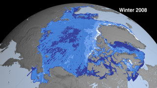
| Using five years of data from NASA's Ice, Cloud and land Elevation Satellite (ICESat), a team of NASA and university scientists made the first basin-wide estimate of the thickness and volume of the Arctic Ocean ice cover between 2003 and 2008. The scientists found that younger, thinner ice has replaced older, thicker ice as the dominant type over the past five years. Until recently, the majority of Arctic ice survived at least one summer and often several. That balance has now flipped. Seasonal ice, or ice that melts and re-freezes every year, now comprises about 70 percent of the Arctic sea ice in wintertime, up from 40 to 50 percent in the 1980s and 1990s. Thicker ice — surviving two or more years — now comprises just 10 percent of ice cover, down from 30 to 40 percent in years past.Sea ice thickness has been hard to measure directly so scientists have typically used estimates of ice age to approximate thickness. With ICESat, NASA scientists were for the first time able to monitor the ice thickness and volume changes over the entire Arctic Ocean. The Arctic ice cap grows each winter as the sun sets for several months and intense cold sets in. The total volume of winter Arctic ice is equal to the volume of fresh water in Lake Superior and Lake Michigan combined. Some of that ice is naturally pushed out of the Arctic by winds, while much of it melts in place. But not all of the ice in the Arctic melts each summer, and the thicker, older ice that survives one or more summers is more likely to persist through the next summer. This older, thicker ice is declining thinner ice that is more vulnerable to summer melt. Seasonal sea ice usually reaches about 2 meters (6 feet) in thickness, while ice that has lasted through more than one summer averages 3 meters (9 feet), though it can grow much thicker in some locations near the coast. From 2003 to 2008, multi-year ice has thinned by an average of 60 centimeters (2 feet). The total ice volume in winter has decreased by 6,300 cubic kilometers, or 40 percent. The maximum extent of multi-year ice is now one-third of what it was in the 1990s. This sequence shows Arctic sea ice thickness derived from winter and fall campaigns from the ICESat satellite. Sea ice grows extent grows in the summer and shrinks in the winter. While the sea ice extent might look similar from year to year this thickness data shows dramatic thinning especially near the North Pole (shown in dark blue). This image was generated with data acquired between Feb 17 - Mar 21, 2008. | ||
| | ||
 | | |


| Magnitude | Mw 6.3 |
| Region | CENTRAL ITALY |
| Abrutian Apennine | |
| Date time | 2009-04-06 at 01:32:41.4 UTC |
| Location | 42.38 N ; 13.32 E |
| Depth | 2 km |
| Distances | 59 km E Terni (pop 110,412 ; local time 03:32 2009-04-06) 7 km NW L'aquila (pop 72,279 ; local time 03:32 2009-04-06) 6 km S Pizzoli (pop 3,378 ; local time 03:32 2009-04-06) |
| Informação em: European-Mediterranean Seismological Centre | |

"O vulcão, que há meio ano não apresentava nenhuma actividade, voltou a entrar em erupção na noite da sexta-feira e regista desde então explosões constantes de material incandescente que se elevam até 600 m, sobre a cratera de 3.210 metros de altitude. Suas actividades aumentaram, no entanto, durante a noite de sábado, conforme atestaram membros do Serviço Nacional de Geologia e Mineração que realizaram ontem um sobrevou sobre a área do Llaima. De acordo com o Escritório Nacional de Emergências chileno, as chuvas deste domingo na região impedem que haja uma visão propícia da situação do Llaima."
"O governo da região da Araucanía decretou alerta vermelho em oito localidades próximas, de onde pretende evacuar umas 70 pessoas devido ao perigo que representa a queda de cinza e escória e a formação de novas inundações."
Os riscos associados à erupção vulcânica são os deslizamentos do barro resultante da mistura de cinzas vulcânicas e escombros com água, que podem provocar um aumento do volume do rio Calbuco. Situado ao sul de Santiago, o Llaima intensificou sua actividade a partir de maio de 2007.
Fonte de informação